Using drones to monitor dikes
All the solutionsPresentation
- Project initiators: A consortium grouping the civil drone operator Redbird (initial project initiator) followed by Geomatys (company specialised in spatialised information processing) with SURVEY Copter (Airbus DS), Entente/CEREN, IFSTTAR, Irstea, IGN, DREAL Centre, Cerema, and DICT.
- Partners: France Digues; Société du Canal de Provence, Compagnie Nationale du Rhône
- Duration of project: 2015 – 2019
Context of how the project emerged:
The Xynthia storm on the Atlantic coast in February 2010 was one of the events that spurred The French public authorities to reflect on the state of the country’s 9,000 km of dikes which protect against the hazards of sudden floods and high sea levels. In 2011, CEPRI estimated that only 3,000 km of all the dikes in France were in good condition. This led to the implementation of new regulatory and security requirements for dikes, which necessitate improving and enhancing the means for monitoring these structures crucial for flood protection.
Strategy and objectives
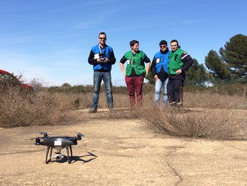

The DIDRO (Dikes by DROnes) project proposes to monitor dikes using drones equipped in particular with image acquisition and analysis sensors. It offers a promising path for more detailed diagnostics of these structures and assisting the bodies responsible for maintaining them in good condition.
The objective is to perform 100% automated centimetric acquisitions with a single registration point on the ground.
DIDRO is a collaborative research project aimed at using drones for low-cost and highly reactive surveying. It fulfils two objectives:
- Regular monitoring to check that the dike does not move and detect different deteriorations, such as a shift or subsidence of the ground, the resurgence of water through the dike, and plants capable of weakening the structure.
- The capacity for rapid utilisation during crises and for surveying dikes over very long distances.
The project’s innovative characteristics
Technical
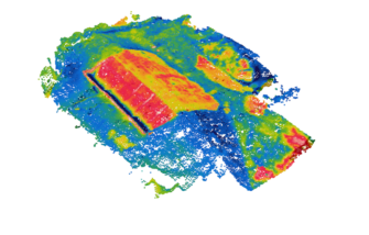
The principle of photogrammetry is to take aerial images that can be joined together photo by photo to produce a 3D model.
Photogrammetry can be used to produce a model of a dike that can be compared over time with successive models to ascertain whether the structure is subject to potential deformation.
The drone is equipped with a conventional camera, a near infrared camera and a thermal camera.

Financial
The drone can monitor areas not accessible by foot and carry out large scale surveys more quickly than a land-based survey (using survey rods) and at lower cost than by plane or ULM. It is therefore a complementary monitoring resource (boat, ULM, etc.).
Results and perspectives
Initially, the drone permits evaluating the state of dikes.
In the long term, the objective is to do without reference points on the ground. Another objective is to achieve centimetric precision while minimising operations on the ground and obtaining better reactivity at lower cost.
This project will result in a commercial solution for using drones to inspect sea, river and canal dikes by drones, as well as for the routing inspection of dikes and strengthened monitoring in the case of major hydrometeorological crises.
DIDRO should lead to a prototype combining two drones (an aircraft type drone, for rapid diagnosis and flood management, and a helicopter drone aimed at in-depth inspection missions), supplied by Survey Copter (a subsidiary of Airbus) with calibrated instrumentation. This prototype will allow flights in winds reaching 60 kmh. The project’s partners plan to market a turnkey technical solution as from autumn 2019, aimed at dike managers. It will be accompanied with a catalogue of the different surveying operations that can be carried out, using the expertise of a company specialised in operating drones.
How can this project be duplicated on other rivers?
This mode of monitoring is very simple and can be used anywhere in the world.
Innovation follow-up
5 years later
The DIDRO project ended in November 2019.
Project progress and results
The withdrawal of the initial project leader from the consortium and the takeover by Geomatys has resulted in a reduction in the time required for experimentation. As a result, the first objective of the project was achieved: 100% of the Work Packages achieved their objectives and resulted in solutions that could be mobilized for dyke monitoring by UAV. However, the second objective, which was to set up a turnkey solution for dike managers, was not achieved. This was due both to the lack of time for the integration of the technical bricks developed by each partner, but also to the industrial protection policies of the partners, who were sometimes competitors in certain markets, which may have hindered sharing.
Nevertheless the project has allowed :
- to consolidate and validate, from a scientific point of view, innovative methods of dyke monitoring by drone.
- validate a system for the rapid and modular installation of instruments on UAVs, according to the needs of monitoring or surveillance of structures.
- to specify doctrines for drone intervention on this type of structure during crisis management.
- develop tools for rapid analysis of data from UAV acquisition campaigns.
A part of the final report of the project can be viewed here:
Les résultats du projet – DIDRO
Distribution
The project has not been set up elsewhere, but steps are underway to exploit the software part independently of the sensors and the UAV so as to open up the field of exploitation to other acquisition modes.
For the time being, each partner is developing the results of the DIDRO project independently and according to its own schedule.
#Drone #Dike #Security #Hydraulicsecurity