The Elbe
Between you and I…
My source lies in the Giant Mountains (Krkonose, Riesenbirge), at an altitude of 1,386 metres. After flowing for 1,094 km, I reach the North Sea near Hamburg. These characteristics means the region I flow through is densely populated: 25 million people live in my watershed which covers 148,000 km2. Can you guess my name? It’s Elbe, from the Latin word Albis, which means river. It couldn’t be more obvious!
A little history
The Romans tried to extend their empire beyond the Rhine to join me. Unfortunately for them, their plan went awry at the battle of Teutoburg Forest in 9 BC. In the Middle Ages I formed the eastern border of the Carolingian Empire. In 804, Emperor Charlemagne granted sovereignty to the Slave peoples living on my east bank but he died ten years later. The Saxons took advantage to invade the Slave territories, an event that heralded several centuries of successive invasions.
Ephemeral fame
Throughout my life, I’ve been honoured to play the role of administrative border. Proud of this success, I’ve lent my name to several administrative districts. The department of Bouches-de-l’Elbe –that’s me!- was created in 1811 when the region was annexed by France. Napoleon’s fall three years later signalled the end of this department bearing my name. The Bouches-de-l’Elbe, whose chief city was Hamburg, corresponded to the territory located in present day Lower Saxony.
“Elbe Day”
“Elbe Day” recalls the day when the American and Soviet troops met for the first time at on my banks at Torgau, northeast of Leipzig, on 25 April 1945 to be precise. The place was chosen for symbolic and strategic reasons. The aim was to maintain the diplomatic balance that had prevailed for two months, a balance found at Yalta between the Allies to divide the vanquished Germany into three occupied zones. So, Elbe Day has been remembered ever since that date.
A river riven by conflicts
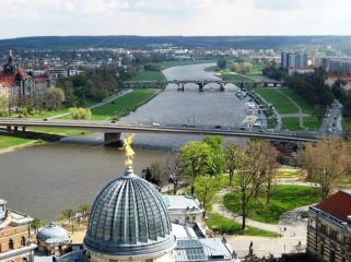
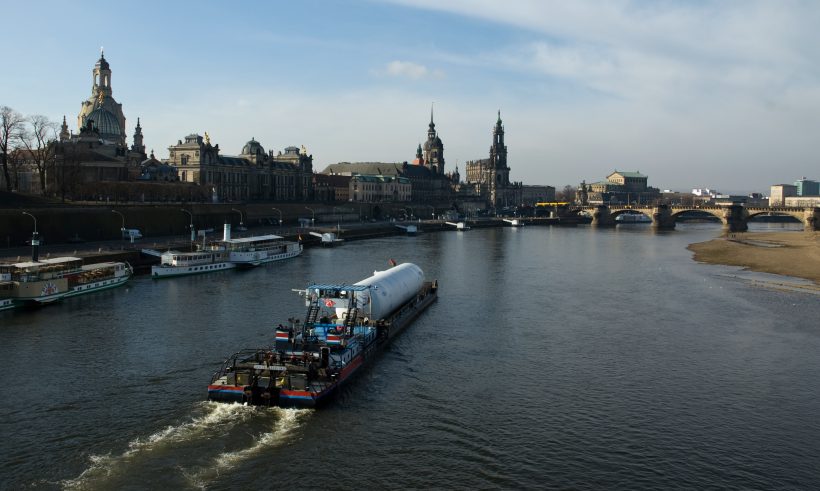
 The towns that stand on my banks have long borne the scars of war. Dresden was the most bombarded city of the Second World War (90% of the old part was destroyed).
During the Cold War, part of my course formed the border between the GDR (German Democratic Republic) and the GFR (German Federal Republic).
Technical sheet
- Source: the Giant Mountains
- Mouth: Hamburg
- Average discharge: 1,800 m3/s
- Total length: 1,094 km
- Watershed: 148,000 km²
- States crossed: Czech Republic (33%), Germany (66%)
- Tributaries: Vitava, Ohre, Schwarze Elster, Mulde, Saale, Havel
Landscape and urban planning: a river of contrasts
From industries to green hills
I do not perhaps share quite the same fame as my sister rivers, but I am no less firmly entrenched in local cultures. I’m reputed to be more nuanced than the Rhine, a warrior river, and the Danube, the river of unity. I also present more contrasts, in the image of the landscapes I cross, between the industries and old open cast mines on the Czech side, and the hills and vineyards of Saxon Switzerland up to Dresden. That’s not forgetting the moors and forests and small towns that formed the heart of the Lutheran Reform of the 16th century.
Towns of character
 The towns and cities I cross are of major importance. There’s Hamburg, which reflects this renewed link between populations, then Magdeburg, reconceived as a river port, and the gateway into the plains of northern Germany. It’s also a city known for leading edge contemporary architectural projects. Towns like Dessau seem to give me the cold shoulder and turn more towards my tributary, the Mulde.
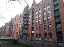
The Hafencity of Hamburg
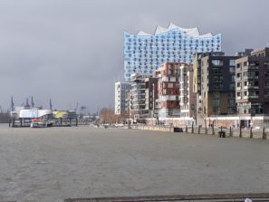

Launched in the 2000s, this architectural and development project will continue until 2025 to create a new district from the old port area covering 157 hectares. It is composed of residential buildings, offices, leisure spaces, shops and cultural facilities.
One of the flagship buildings of this complex is the new Elbphilharmonie concert hall completed in 2016.
This project not only allows the city of Hamburg to expand up to the Elbe, but it provides new quality to urban life in the city and a new relationship with water in its centre.
My many uses
A waterway for trade
A waterway for people and trade, I was of crucial importance during the expansion of the Hanseatic League, and even up to the 19th century. During the first half of the 19th century, the rail link between Hamburg-Berlin-Dresden-Usti and Labern-Prague started to compete with me. However, during recent decades national German and Czech strategies have wagered anew on river transport as a tool for international development.
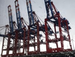
 The port of Hamburg is now a transit hub for the whole of Eastern Europe, for the Baltic and for Germany: 1/3 of goods are destined for a radius of 150 km around Hamburg. It is also the transit point for exports made in Germany and its neighbouring countries.
Links to the hinterland are mainly ensured by railway (45% of the goods transported) and road (43%). The port of Hamburg manages 300km of railway and three freight marshalling yards!
Hamburg, 3rd largest European port
The development of Hamburg is linked to the activity of its port. In the 13th century, maritime trade became more organised with the formation of the Hanseatic League. This alliance between the trading cities of Northern Europe was organised in particular around the cities of Hamburg and Lubeck.
Hamburg is now Europe’s 3rd largest port and the 26th largest in the world in terms of size and traffic. It stands in 14th place on the world podium if only container traffic is considered. Its development has accelerated in recent years.
The port manages from 35% to 80% of freight from and to Poland, the Czech Republic, Hungary, Austria, Germany and Denmark. It is also the second point of entry into Europe, after Rotterdam, for containers shipped from China (nearly 1.4 million containers).
The port of Hamburg is also increasingly involved in the cruise industry.
Irrigation and agriculture
No fewer than 312 dams have been built in my basin, distributed between Germany and the Czech Republic, for the purposes of irrigation! 40% of my watershed is used for agriculture.
Key figure:
4.12 billion m3: the total volume of water held in the basin’s reservoirs
What river for tomorrow?
Water pollution: collective awareness
I was one of Europe’s most polluted rivers until 1990; effluents from both Germany and the Czech Republic ended in my waters, not to speak of pesticides from farming. But the quality of my water has greatly improved since the reunification. There is still some way to go however to reach the targets of the EU’s framework directive on water by 2027.
An international commission to protect the Elbe from pollution
The International Commission for the Protection of the Elbe River (ICPER) was set up in October 1990. It gathers the Czech Republic, Germany and observer countries and organisations (including the European Union). Its objectives are to:
- make different uses of water possible,
- achieve a natural ecosystem capable of ensuring the development of the fauna and flora,
- reduce the burden of the Elbe basin on the North Sea.
The works of the ICPR are oriented around:
- water quality: in 29 years the quantity of chemical products discharged into the river has fallen by 809,000 a year. 94% of the Elbe’s course on the German side has been placed under ecological protection;
- flood protection;
- setting up an information communication system for the surrounding population in the case of an accident.
Floods and hydric stress: the impacts of climate change
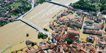
 My floods have marked history. In February 1962, the flood of the city of Hamburg remains that most tragically remembered for the number of victims claimed (more than 300 deaths). One of the impacts of climate change could be stronger floods or at least more episodes of extreme rainfall.
A program has also been launched to evaluate the economic and social impacts of hydric stress in my watershed for a timeline of 2052.
The competitiveness of inland waterways must be improved
River transport to serve the hinterland is hampered by the lack of infrastructures and multimodal hubs. It must above all face highly efficient competition from the railway system. The transport of goods via the river almost exclusively concerns inland transport in Germany, since the other modes of transport predominate for international transport.
The master transport plan has set out new directions to renew river infrastructures and thus develop traffic.