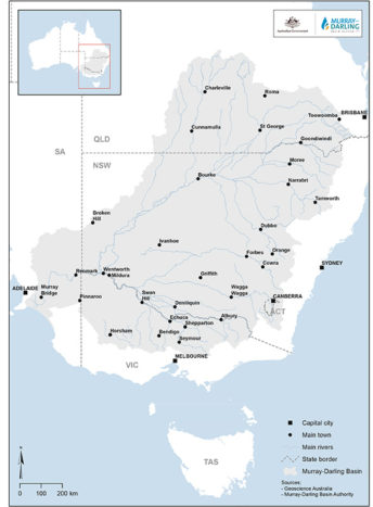
The Murray-Darling Basin
Between you and I…
With my surface area of 1,072,000 km2, i.e. 14% of the Australian continent, I am the country’s largest hydrographic network. My name? The Murray-Darling Basin. Let me enlighten you with my Australian accent: I am a citizen of the driest inhabited continent on Earth, Australia. My basin in the southeast attracts 90% of the population, with the rest of the continent mostly occupied by deserts. I encompass no less than 70% of irrigated land and 40% of my country’s agricultural production. But that doesn’t protect me from the shortages that affect Australia, caused by climate change, or a lifestyle and economy that consume particularly large volumes of water.
A little history
 Called “Millewa” by the Aborigines, I bear the name of the two main rivers that cross me. I was exploited very early, from the beginning of the 19th century, to become a waterway and an instrument for developing trade with my faraway cousins in Europe. By developing my different uses, human beings have contributed to unsettling an already very fragile ecological system. The cause: pumping and diverting my waters for irrigation and cities, not to speak of land devoted to grazing and deforestation, which have degraded the quality of my water, with the two phenomena of soil acidification and salinization.
What is more, starting from the 2000s, unprecedented water shortages, i.e. hydric stress, began to occur.
The danger is there: I have always been a rare and precious resource due to the country’s geology (small differences in level) and its hot and semi-arid climate. It was necessary to totally rethink my governance to avoid disastrous environmental social and economic impacts. I’m now the focus of every attention and a lever for innovations aimed at rationalising and optimising the use of my water.
Technical sheet
- Source: Australian Alps.
- Mouth: Indian Ocean.
- Average discharge: 450 m3/s (Wentworth); 0.89 m3/s (mouth).
- Total length: 3,370 km (including 2,530 for the Murray).
- Watershed: 1,072,000 km².
- States crossed: New South Wales, Queensland, South Australia, Victoria and Australian Capital Territory (Canberra).
- Tributaries: Murray, Darling, Dachlan, Murrumbigee River.
My many uses
I was already the centre of discussions between the different parties managing me in the 1870s, namely the States, aware of the shortage of water confronting farmers and the need to turn me into a trade route.
The farmers’ revolts in the rural areas of the Murray valley at the beginning of the 20th century, led the authorities to undertake a huge water management programme based on building dams and pumping stations.
Navigation: a little used waterway
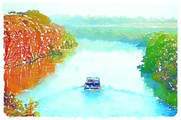

Although navigation flourished on my waters at the end of the 19th century with the transport of gold and wool, my weak discharge and meandering course do not facilitate river traffic. I quickly came into competition with the railway.
Today, my Murray river is used by pleasure boats and for nautical sports.
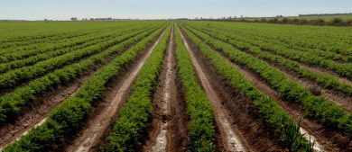
Agriculture, a major consumer of water
Agriculture is the oldest activity practiced along my course and by far the largest consumer of water. Australia is an important cereal producer and one of the largest producers of meat in the world.
The agricultural sector is under constant pressure to adapt to international competition and a lack of resources. Improving water management in rural areas has been declared a national priority.

Agriculture in Australia
- Employs 3% of the active population;
- A trade surplus, with 60% of farm produce exported;
- Irrigated farming covers a surface area of 2 million hectares, mostly in my basin;
- 25% of the gross value of total agricultural production: that’s the value of irrigated agricultural production, which however represents only 0.5% of the country’s farmland.
Supplying cities with water

 Adelaide and its 1.1 million inhabitants – the country’s 4th largest city – the steelmaking area of Port Augusta, and many of Australia’s rural regions depend on my water.
Faced with the reduction of their water reserves, Australia’s large cities have had to adapt by setting up new supply systems and restrictions on consumption that vary
 depending on the level of alert; and by diversifying sources by experimenting with new solutions (storage in aquifers, rainwater collection, recycling and desalinization, etc.).
89% of the country’s 23 inhabitants live in urban areas.
101234567890401234567890
% of Australia’s surface area
401234567890
large artificial water reservoirs
101234567890
st water access rights trading system established in the world
Hydroelectricity production at the forefront of renewable energies
The reduction of available water resources is a major constraint for hydroelectricity production, which should see its share of the national energy mix, mostly dominated by coal, fall from 5 to 3.5% by 2030.
Nonetheless, hydroelectricity is the leading renewable energy in the country. Around a hundred hydropower plants generate more than 18 TWh a year. The future relies on the construction of two types of very small hydropower plant:
- run-of-the-river, without dams or storage reservoirs;
- using existing dams intended to supply water, controlling water levels and irrigation.
Energies in brief: fossil fuels way ahead
- Australia exports about 68% of the energy it produces, mostly from coal and gas. It has 10% of the world’s coal resources (the second largest reserve after China), and nearly 2% of the world’s conventional gas resources
- The mining sector represents 10% of the Australia’s GNP and 248,000 direct jobs.
- Every year, the exploitation of the country’s mineral resources consumes 4% (about 600 gigalitres) of the available water. Since most of the sites are located in arid and remote areas, securing water supplies is a crucial issue for the country.
- Renewable energies make up 7% of the energy mix (hydroelectricity and wind power). Australia must make major efforts to reach its target of a 26% reduction of greenhouse gas emissions from now to 2030 versus 2005.
What river for tomorrow?
A fragile ecosystem
Today, the massive exploitation of resources, primarily for irrigation, is obliged to take account of increasingly frequent drought episodes while the conversion of land for grazing and deforestation participate in the acidification of soils and the salinization of water. The conditions of supplying water for the different sectors of activity are continually worsening, in terms of both quantity and quality. Globally, the withdrawals are increasing at a rate of 1% a year in the basin. The pressure on water resources is especially high in the cotton growing area of the north.
The economic challenge is to satisfy needs while freezing new sources of withdrawal in order to limit the causes of environmental degradation.
A political response was made with the Water Act in 2007 which led to the founding of a single federal body devoted to my management: the Murray-Darling Basin Authority. This law introduced major positive changes such as the creation of the water access rights trading system, the reduction of irrigation permits and higher water prices. This policy has already led to a 50% reduction of water consumption at constant production. In addition, the MDBA’s basin scheme has determined a long-term management plan for the entire basin for a period of ten years.
Laboratory of adaptation to hydric stress
The action of the public authorities, backed by scientists, and the snowball effect on private actors have made Australia a land of experimentation, reforms and innovations intended to rationalise water use. Technological solutions are being tested, and which are changing me into a genuine laboratory in the combat against hydric stress, with more water thrifty systems; desalination processes; tools to prospect for underground water, and so forth.
However, the country is still has the world’s 3rd largest consumption of water per inhabitant.