Seine
Between you and I
A French river, I cross 13 departments and 400 municipalities. Paris, city of light, spreads out from my banks. Covering 79,000 km², my watershed encompasses nearly 30% of the French population. I am the Seine!
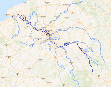
 My source lies in Côte-d’Or, at an altitude of 452 m, before flowing 777 kilometres northwest. At the end of this journey my waters flow into the English Channel via a 16 km wide estuary between Le Havre, a strategic commercial port for Europe since the 16th century, and the bay of Honfleur.
In a context of globalisation and busier river-maritime trade, the issues of the competitiveness of the corridor I ensure between Paris, Rouen and Le Havre, and the protection of my environmental health, have become more urgent than ever.
The Seine’s vital statistics
- Source: on the plateau of Langres, in Côte-d’Or
- Discharge: 563 m3/s on average at Le Havre
- Length: 777 km
- Watershed: 79,000 km²
- Regions crossed: Bourgogne-Franche-Comté, Grand Est, Île-de-France, Normandie
- Main tributaries: Oise, Marne, Yonne
A little history
My name comes from “Sequana”, a goddess of the Celts of Gaul. This nymph, protector of my waters, was endowed with the gifts of healing and granting wishes.
Archaeological studies prove that humans have lived on my banks since prehistoric times. Structures such as wooden pontoons and stone landing stages to give people access to my waters date back some 6,000 years.
In the Middle Ages, lordly manors were built close to my banks: Bercy, Conflans and Choisy. Paris became a trading city and the centre of royal government; its supply became crucial and I was to contribute. Boats propelled by poles or pulled by animals hauling from the river banks plied my waters, but I remained difficult to navigate, due to the instability of my banks. I can also be an impetuous character. Between 576 and 2016, I have left my bed sixty times, and flooded many towns. My hundred-year flood in 1910 was particularly severe*.
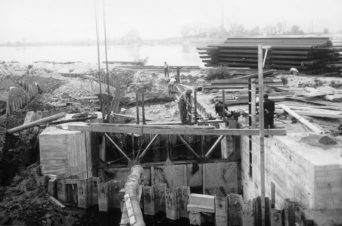

Starting around the middle of the 18th century, numerous works were begun to make me navigable: my bed was deepened, fords were replaced by dams-locks in Paris and Rouen. Progressively, ferries were replaced by bridges. In the middle of the 20th century, my course was controlled and I became navigable for the transport of large volumes of goods. But I was in competition with road transport and my popularity as a transport corridor began to decline in favour of road transport in the 1970s. However, now there’s no avoiding me: an industrial river, I play a key role in the territory called the Seine Valley that encompasses nearly a third of France’s GDP and 6 million jobs. 40% of national river freight is carried on my waters. A geographic and cultural entity, I’ve also shaped the history and landscape of the valley I cross.
* a hundred-year flood is a flood that, each year, has 1 chance in a 100 of occurring.
My uses
Whether it’s for transporting goods, tourism, or supplying drinking water, human beings have placed me at the heart of a whole array of activities.
River transport
In 2019, 23.7 million tonnes of goods were transported along my course, in other words 40% of national river freight. This traffic represents an increase of 10% in comparison with 2018. It is mainly driven by two sectors: construction, with 65.7% of the volumes transported, and agri-foods, with 15.4% of the volumes transported.
Three large ports lie along my course: Le Havre, Rouen and Paris. They will soon be gathered under a single management: Haropa. This ensemble will be France’s leading port network for foreign trade.
The Seine-North Europe Canal
This European project is aimed at linking the Seine basin with the Escaut river. The canal will cross France, Belgium and the Netherlands, before ending its journey in the North Sea. Completing the river transport network at the European scale, it will provide an alternative to the transport of goods by road along the north-south axis.
Tourism
I am Paris’s fourth most popular tourist site, with economic spinoffs estimated at €130 million in 2018! 125 companies offer excursions on my water in Île-de-France and 3 in Normandie.
Drinking water supplies
With the Oise and the Marne, I contribute 40% of the Île-de-France region’s drinking water supply. Eau de Paris conveys drinking water to 3 million users while the Syndicat Interdépartemental pour l’Assainissement de l’Agglomération Parisienne (SIAAP) treats 2.5 million m3 of wastewater every day for 9 million users in a territory covering 1,800 km2.
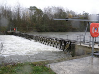

Hydroelectricity production
Little attention has been given to my potential for electricity production up to now. In 2016, Voies navigables de France (VNF) launched a series of projects for small hydropower plants to exploit the heads of dams and locks along the corridor formed by the Seine, Marne and Oise.
By 2022, 10 small hydropower plants generating 58,000 MWh a year will satisfy the electricity consumption of 22,000 households.
Four reservoirs at the heart of the basin
Excavated to absorb floods during the winter and sustain river discharges during the dry season, four large reservoirs were filled with water during the 20th century. They can store more than 800 million m3 of water, allowing the Établissement Public de Bassin (EPTB) Seine Grands Lacs to fulfil its missions: flood prevention, managing water resources fairly and sustainably, preserving the biodiversity of aquatic ecosystems and wetlands.
Envisaging the future
Preserving my health
Although the quality of my surface waters has improved, that of my groundwater is alarming. Only 28% of my groundwater is considered to be of good quality. This pollution is mainly due to intensive cereal farming in the Seine basin, started in the 1950s. Thus, the aquifers have been polluted for a long time and this pollution is persistent: although no longer used, certain fertilisers and pesticides are still found today in the groundwater. The pollution of aquifers can also be explained by discharges of partially treated wastewater containing residual solvents, drugs, heavy metals, etc. This has had considerable effects on biodiversity: microbial life has diminished as has that of populations of insects and birds.
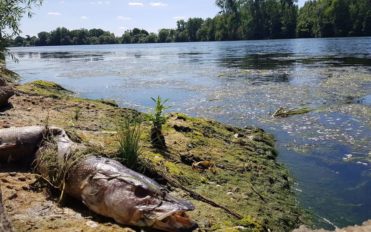

Lastly, rainwater runoff on soils often made impermeable in urban areas drains pollution into rivers. The volume of runoff during heavy rain threatens to saturate drainage networks, leading to dysfunctions and pollution. To prevent this, SIAPP has built 26 floating dams to “capture” the solid waste drifting on my waters. “Survival islands” equipped with an oxygen reservoir are triggered when my water is no longer sufficiently charged with oxygen, during heavy storms and summer heatwaves.
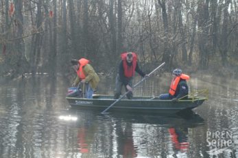
The quality of my waters is improving thanks to the combined actions of different actors featuring in the Water Management and Development Master Plan (SDAGE): the number of fish species identified in my water has increased from 3 to 32 since 1970.
Restoring natural habitats
The accumulation of structures has made my waters less propitious for the healthy development of nature. Movements of sediments and species have been impeded and habitats damaged. The drainage of agricultural land has led to the disappearance of wetlands, vital links for the water cycle, water quality and the management of extreme episodes such as floods and droughts. Between 2013 and 2018, nearly 500 dams were eliminated in the Seine-Normandie basin to facilitate the circulation of fish and sediments. 4,500 km of river were restored, allowing the recolonisation of water by species sensitive to pollution, such as trout, salmon and European bullhead.
Reconciling economic activities and habitat protection
Tourism, agriculture and port activities are sources of economic development. They can also generate negative impacts on my environment due to waste fuels and excess fertilisers. Ironically, these pollutions in turn jeopardise economic development: for example, green algae threatens tourism, fishing and shellfish farming.

To combat these many but related challenges, I can count on remarkable and long-lasting cooperation between scientists and those responsible, with PIREN Seine, for managing the water in my basin. Relying on a multidisciplinary scientific approach, the program has led to the development of tools and methods to understand how the basin functions, linking the flows of water and materials to the lifestyles of the populations living in the region, and thus providing a common vision and better qualitative and quantitative water resource management.
Anticipating the effects of climate change
Rising seawater levels, coastal erosion, the intrusion of salt in groundwater, drought episodes, floods, etc., climate change augurs difficult situations that require preparation, notably through operations to restore natural habitats, water thrifty practises and developing new modes of managing extreme episodes.
For more information
The Interdisciplinary Research Programme on Water and the Environment of the Seine River Basin (PIREN Seine), is celebrating its thirtieth anniversary with the publication of a scientific work on the French river. This interdisciplinary analysis, produced by a collective of researchers, is published in the Handbook of Environmental Chemistry, edited by Springer. Find this book in free access to learn more about the Seine.