The Senegal river
Between you and I
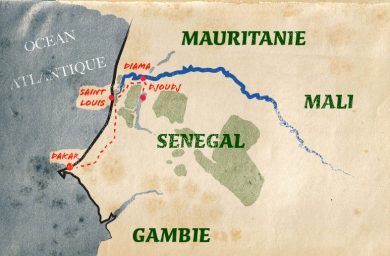
My name certainly rings a bell, and rightly so. I belong to the world’s great rivers. I am the Senegal River, the umbilical cord between Guinea, Mali, Senegal and Mauritania in West Africa; whose source lies in Guinea with the rivers Bafing and Bakaye that converge at Bafoulabé in Mali.
After having crossed the western part of Mali, I join the Falémé, my main tributary, and form for the rest of my course the border between Senegal and Mauritania. I then flow onwards to finally join the Atlantic Ocean at Saint Louis. I might appear rather big-headed but, between ourselves, my importance in a region hit by severe droughts quickly strengthened the need of the four countries of the basin to cooperate in favour of my development, to the point of setting up a unique international system, and still the only one of its kind regarding river governance. Would you like to know more?
What if we got to know each other better?
Technical sheet
- Discharge : 640 m³/s (from 3 m³/s to 5,000 m³/s)
- Length : 1,700 km
- Watershed : 337,000 km²
- Countries crossed : Guinea, Mali, Senegal, Mauritania
- Main tributaries : Kolombiné, Karakoro, Gorgol, Bafing, Bakoye, Falémé, Baoulé
 A little history
I started attracting attention at the beginning of the colonial era in the first part of the 19th century. You wouldn’t be surprised if I told you that my development gave rise to questions. It wasn’t until 1892 that the first full studies on me were performed. From then onwards, several successive bodies brought together the neighbouring countries but no real progress was made until independence was achieved between 1958/1960.
In 1963 and 1964 conventions regarding my status and development were signed, signifying my arrival into the club of the great (rivers). This is without taking into account the episodes of severe droughts that hit the region between 1968 and 1973, and which strengthened the need for cooperation between the neighbouring countries.
In 1972, thanks to an agreement between Senegal, Mali and Mauritania, the World Organisation for the Development of the Senegal River (OMVS), also known as your servant, was founded. Guinea quickly joined this organisation.
A unique model at the world scale, the OMVS has granted me the prestigious status of “international” resource. I have not only become polyglot, but I also provide unhindered navigation along my course and equality between countries regarding all the uses of my water. Who wouldn’t want to get on board!
The OMVS was founded with three basic principles: the river and its tributaries are international property; the exploitation of their resources is shared communally; all the structures are owned in common. The goals of the organisation are to:
- Achieve food self-sufficiency for the basin and the sub-region’s populations.
- Secure and improve their incomes.
- Preserve the balance of the ecosystems.
- Reduce vulnerability to severe climatic hazards.
- Exploit the hydroelectric potential of the basin to the benefit of the member States.
- Speed up economic development.
Over time, the OMVS has become a reference around the world. In 2016, it was named the best basin organisation in the world for the quality of its programmes and its model of shared water management in the framework of community cooperation. It provides the permanent secretariat of the African Network of Basin Organisations.
The flow of the Senegal River: user’s data
What ?
The rainfall in the Upper Basin provides the main part of the river’s flow regime:
- July to October: rainy season, high water levels.
- November to May/June: dry season, low flow.
Where ?
- The Upper Basin (Fouta-Djalon to Bakel): the rains from April to October, occurring in the mountainous part at the most southerly point of the basin, cause annual flooding of the river. Annual rainfall varies from 700 to 2,000 mm.
- Valley (Bakel to Dagana): this alluvial agricultural plain, bordered by semi-desert regions, is fertilised by the flooding of the river every year.
- Delta: this vast flat area is submerged by salt water from the ocean during the dry season.
 A source of life, I serve myriad uses
Agriculture and irrigation
My watershed is large (337,000 km²) and hosts three types of farming:
- Under rain: in the upper basin, with mostly food crops such as millet, maize, sorghum (cereals, etc.) and water melon.
- After subsidence: maize, aubergine, pumpkin, tomato, hibiscus (bissap), sorghum, rice, water melon and other local market garden products are the joy of the inhabitants of the surrounding towns and villages. This type of traditional agriculture is tending to lose importance due to the flood management policy, much to my dismay.
- Irrigated land: I now provide water for 137,800 ha of land and the potential is even greater.
There are two predominating types of irrigated crops:
- Cereals of which rice is by far the main crop.
- Horticultural produce, especially onion, tomato, melon and gumbo.
501234567890.201234567890501234567890
billion of m³ of water for agricultural production by 2025
Water for all
Vital for the populations that live along my course and on the lands I cross: my water is a precious commodity.
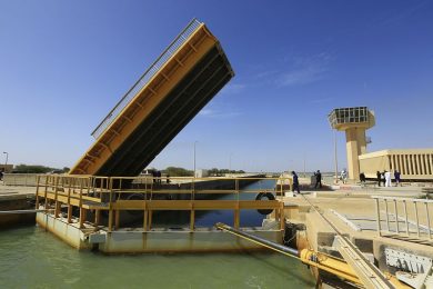
 Drinking water, for example, is necessary for my dear inhabitants. Thanks to the Diama dam, the drinking water of the large cities like Dakar, Nouakchott and Saint Louis is secured. Built in 1986, 30 km from the mouth of the river, it is used to stop the reflux of salt water and to store 500 million cubic metres of water. Since the end of 2011, I have supplied nearly all the needs of the city of Nouakchott, located some 200 km from the dam under a desert climate.
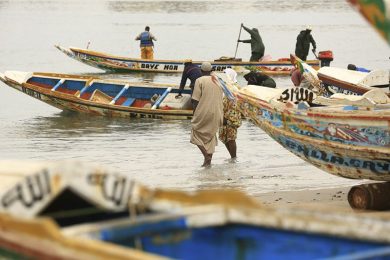
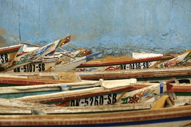
Livestock breeding, like fishing, is of primordial economic importance. It involves an average of 60% of the rural population in each of the neighbouring countries. As for its contribution to the GDP of the different countries, it varies from 4% to 12%. The development of livestock is one of the orientations determined by the member States of the OMVS, in the framework of the combat against poverty.
Let’s be honest: the industrial fabric I am involved with is relatively weak. The Compagnie Sucrière Sénégalaise (CSS) is the only large company that operates in my basin (sugar cane and some tomato processing plants). Only the removal of the barriers (to the river’s navigability, the construction of port infrastructures, etc.) will facilitate the exploitation of economic sectors in each of the three countries of my basin.
101234567890301234567890001234567890
million m³ for drinking water consumption by 2025
801234567890401234567890
million m³ of water for livestock breeding by 2025
201234567890301234567890501234567890
million m³ of water needed for industry and mining in 2025
Hydroelectricity
Although irrigation is the major challenge in the management of my waters, the member countries of the OMVS are increasingly staking on hydroelectricity. It even appears that it will help to offset their energy deficit, diversify sources of production and favour their industrial development. An infrastructure programme has been drawn up to regulate my discharges and produce energy with the construction of hydropower dams. Studies have allowed identifying the potential sites for the dams and begin their construction.
The OMVS currently has two hydropower structures:
- The Manantali hydropower scheme (the dam and its power plant, 2002) located on the Bafing, in Mali. With an installed capacity of 200 MW, it produces an average of 800 GWh/year delivered to the national electricity companies of Mali (52%), Mauritania (15%) and Senegal (33%).
- The hydropower plant of Félou (2013), also in Mali. This is a run-of-the-river plant with an installed capacity of 60 MW. It produces from 320 to 350 GWH/year which are injected into the grid of Manantali.
The energy produced is transported to the countries by the interconnected transport grid of Manantali (RIMA), 1,700 km long. To date, the total installed capacity of the RIMA is 260 MW. On the completion of the “second generation” projects which involve 5 new structures, the OMVS’s energy system will reach an installed capacity of about 2,000 MW.
Hoist the mainsail
 As far as the celebrity of rivers goes, I’ve had ups and downs. My hour of glory takes us back to the beginning of the 20th century, when I was considered as a flourishing means of transportation. The slump was sudden when, in 1970, this activity became scarcer until almost stopping, due to the total lack of investment to sustain competition with alternative transport modes (road, rail, etc.) and considerable variations in my hydraulic regime.
One of the OMVS’s priorities is the restoration of durable navigation between Saint-Louis and Ambidédi, meaning a stretch of navigable path for 905 km! This implies major dredging works to develop the channel, building a river-maritime port at Saint-Louis, building or restoring wharves on both banks, and so forth. These projects have been studied for over 40 years and my managers hope to launch them soon to strengthen my role as a lever for the development of the regions I cross.