The Mississippi
Between you and I…
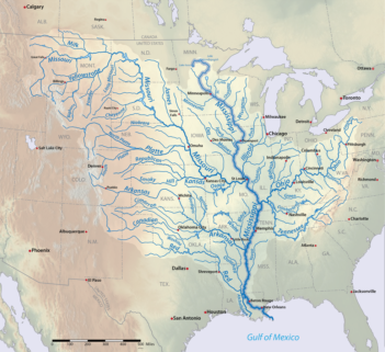
 After the Amazon and the Congo, and counting my tributaries, I am the world’s third largest river if my major tributary the Missouri is taken into account. My name means “the father of waters” in Amerindian, but I am above all known as the Mississippi. My source is Lake Itasca in Minnesota, in the north of the United States. My watershed covers 41% of the central part of the country before reaching New Orleans in the deep south, where I flow into the Gulf of Mexico. A raindrop falling in the lake Itasca needs approximately 90 days to join my delta!
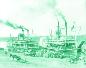
I am the pride of my country, and an integral part of American culture and the collective imagination, with my paddle steamers (with huge bladed wheels used for propulsion), and the images of adventures and gold prospectors I evoke. There are also less seductive images of slaves forced to work in the cotton plantations for over a century, up to the American Civil War in 1865.
 Today I’m an essential corridor of the American economy, providing irrigation for cereal crops, water for cities and industries, and some of the busiest ports in the world like those of New Orleans and South Louisiana. The other side of the coin is that my waters are not always used rationally and are subject to pollution and over-consumption, while the impacts of climate change are having serious effects on my ecosystem.
A little history
In the 18th and 19th centuries, farming flourished in my alluvial plain while New Orleans became a hub of international trade. But the region still remained vulnerable to regular floods that hindered economic development.
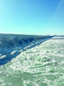
 The first major works were carried out around 1875 to reduce the effects of flooding, promote navigation and combat the erosion of my banks. It was especially following the severe floods of 1927 and 1933 that my development accelerated with the construction of 37 dams and locks.
Technical sheet
- Source: lake Istaca (Minnesota)
- Mouth: the Gulf of Mexico, with a 75,000 km² delta in Louisiana
- Average discharge: 17,545 m3/s (mouth)
- Total length: 3,780 km
- Watershed: 3,238,000 km²
- Country crossed: the United States
- Tributaries: Ohio (left bank), Missouri, Arkansas, Red River of the north and the White River (right bank)
My many uses
Agriculture: 200 years of intense activity
For nearly two centuries, agriculture has been the main human activity on the land of my basin. Farm production now covers 71% of my basin and the major agri-foodstuff industry that has developed produces 92% of the country’s farm exports and supplies most of the country’s beef and pork.
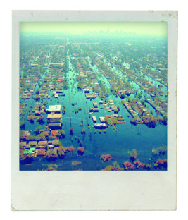
In the lower region of my basin (from Saint-Louis to New Orleans), the agricultural sector is the third largest contributor to the regional economy, with dynamic activities like cereal production, livestock breeding, and aquaculture. After industry, intensive irrigated farming is the second largest consumer of water. During the severe floods of 2011, the loss to agriculture in this region was estimated at $600 million!
Cities and industry: pressing needs for water
 I’m also useful to the daily lives of populations and the numerous industrial activities present in my basin. More than 50 cities and 18 million of people depend on me and my tributaries.
My waters are mostly used for the operation of a large number of coal and oil fired, biomass and nuclear power plants. The paper industry, oil refining and processing, chemicals, agri-foodstuffs and transport also depend on my hydrological system. This human and industrial overexploitation leads to increasingly frequent water shortages, especially in the southeast and the States of Arkansas, Tennessee and the lower Mississippi.
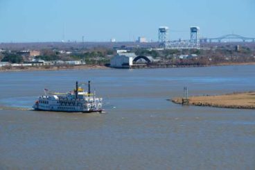
Navigation: 500 million tonnes of goods!
10% of the United States’ goods transit on my waters which also carry 60% of its cereal exports via the ports of New Orleans and south Louisiana. Oil products, iron, steel, wood, coffee, chemical products and vegetable oils are also transported. In all, nearly 500 million tonnes of goods every year!
Hydroelectricity production: hardly harnessed
I’ve above all been used for transport, contrary to my cousin the Tennessee which was developed as early as the 1930s with three objectives:
- Navigation
- Irrigation
- Electricity production.
 However, the potential for hydroelectricity is there. In these regions where energy primarily comes from coal, oil and natural gas, the development of renewable energies is a real opportunity and private companies are already lining up. All that’s missing is the political will!
A new tourist economy
With industrial and tourism activities I alone generate 1.5 million jobs. The industrial sector is by far the largest since it gives rise to a third of the jobs in the valley. But some old industrial cities have taken a downturn. Luckily, tourism is thriving, with the development of river cruisers.
It provides a new source of income that encourages the local authorities located along my banks to take care of the surrounding natural spaces. These forests, wetlands and other natural spaces, the lungs of biodiversity, also protect cities against floods and conserve water in times of drought.
901234567890201234567890%
of the nation's agricultural exports in the Mississippi basin
501234567890001234567890
cities rely on the Mississippi for daily water supply
201234567890601234567890001234567890
species of fish surveyed
What river for tomorrow?
The Mississippi River Commission (MRC), a federal commission responsible for developing and monitoring the Mississippi, has identified three main challenges for my future:
- the adaptation of navigable waterways to competition,
- the identification of solutions for floods,
- the development and implementation of programmes that respect the environment while taking into account the economic realities and vital needs of the people.
Mention can be made of two other major challenges that call into question the entire American model of development:
Pollution: an entire ecosystem to be protected
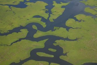
With 650,000 km² of marshes, I form the largest continuous system of wetlands in North America. The high floodable plain of the Mississippi is the largest national nature reserve in the Midwest. I accommodate at least 260 species of fish and I serve as a migration corridor for many birds.

However, the pollution of my waters is a major concern. The guilty parties: the phosphorous and nitrogen contained in the fertilisers and wastewater resulting from agricultural and industrial activities in the region. They prevent the growth of plants and exacerbate soil erosion and floods.
Measures to protect the region, in particular the restoration of my delta and the protection of New Orleans, have been taken to protect ecosystem, implement ecological management of the structures and educate local communities. But are they enough?
“The Dead Zone” in the Gulf of Mexico
In the Gulf of Mexico, there is a zone covering 22,000 km² subject to a shortage of dissolved oxygen (the quantity of oxygen in solution in water required for plant and animal respiration), that suffocates fish and any form of aquatic life. Researchers have named it the “Dead Zone”. It was the fishermen who sounded the alarm, concerned by their meagre catches of fish and shellfish. The reasons: the rise in the water temperature, intensive agriculture, with the use of pesticides and fertilisers that flow into the river which then flows into the Gulf. Initiatives have been taken to limit the spread of this zone, notably with the use of filtering dams, though reducing it appears problematic at present.
The inevitable rise of the water level
In Louisiana, the bayous between the land and the water are vanishing. The situation is critical and changing very quickly as the sea level rises and coastal erosion worsens. Then there are the effects of the infrastructures built by man: up to 41 km² of coast is lost every year, with blue replacing the green.

Of the countries most exposed by rising water levels the United States stands in 11th place: 18 million Americans now live in a zone at risk, i.e. 6% of the population. What’s more, the Gulf of Mexico has been hit by 9 of the most destructive hurricanes recorded in the country over the last 170 years, most during the past decade…