The Rhone
The Rhone in Switzerland
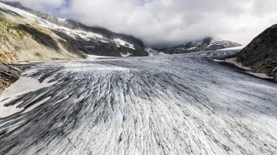

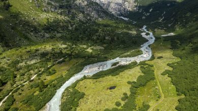
My source springs from the glacier that bears my name, on the Furka mountain, in the Saint-Gothard massif in westernmost Valais, at an altitude of 2,300 m. I then cross the canton of Valais for 164 km, before flowing into Lake Geneva. At its outlet, I flow for another 25 km before reaching France.
My history with the population is troubled: although everything occurred smoothly until the middle-ages, I then became more dangerous and unpredictable; the inhabitants built dikes to prevent my surges, and my dynamics were studied as early as the 16th century. It was then that the major developments began.

“Corrections” to protect the population from my floods
In the 18th century, the economy of the Valais suffered due to my floods. Thus, humans undertook to “correct” me. The first projects comprised dikes; marshes were dried and turned into fields for cultivation. This policy continued at the beginning of the 20th century: the height of my dikes was raised and my bed narrowed to increase the bedload. These strategies resulted in separating me from those that populated my banks, without however providing reliable and satisfactory protection against my floods. Since 2009, with the third of these corrections, 160 km of my course was redeveloped, from my source to Lake Geneva. This time, humans decided to give me room at certain places, by widening and lowering my bed. The challenge was threefold: the restoration of natural habitats, flood protection, and the reappropriation of my banks by the surrounding population. I have come back into people’s lives, thanks to the development of leisure sites.
The power of my water
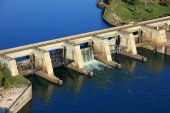
My discharge was first used in the canton of Geneva in the 15th century to drive watermills. In the middle of the 19th century, my energy was used to produce electricity: hydropower dams were built in the canton of Geneva and that of Valais, providing the latter with its main source of wealth. It produced 10 billion kWh of hydroelectricity every year, representing between 25 and 30% of Swiss production thanks to hydropower dams in the high central mountains and 5 run-of-the-river hydropower plants.
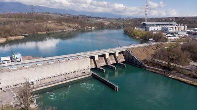
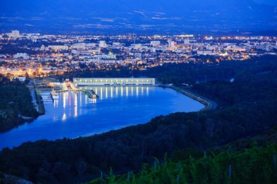
In the canton of Geneva, I drive three hydropower plants operated by the Services Industriels de Genève (SIG). The first of them, at the outlet of Lake Geneva, is the dam of Seujet. Its annual production is quite low, with 25 GWh. It above all participates in regulating the level of the Lake Geneva and permits adjusting my discharge. Thus, the dam of Verbois, located downstream, can adapt its electricity production and supply more during periods of high demand. It has an annual output of 466 GWh. Lastly, the French-Swiss dam of Chancy-Pougny produces 250 GWh/year.

Governing me is an art
I am managed by a large number of organisations, at both federal and cantonal levels.
Upstream of Lake Geneva, I belong to the federal office of the environment (OFEV) while downstream, I am owned by the Canton de Geneva.
- I am managed by two organisations at the federal level: the OFEV for environmental aspects, and the federal energy office (OFEN) for aspects concerning electricity production.
- The 3 cantons of Valais, Vaud and Geneva also participate in my management and work together on my 3rd “correction”.
This is not forgetting two industrial actors: the SIG, which produces electricity, distributes heat, gas and water, and manages waste and telecommunications. It is responsible for the operational management of the hydroelectric structures of Seujet and Verbois. The Société des Forces Motrices de Chancy-Pougny is responsible for the dam of Chancy-Pougny.
The Rhone in France

The most powerful French river, with a discharge reaching up to 1,800 m3/s, I am the king-river: since antiquity, I have been a major corridor of exchange and trade. I also became an important supplier of energy in the 20th century. For long untameable, my floods caused severe floods that destroyed everything in my path in 1840 and in 1856. Humans decided to start works that were initially intended to protect them against my fury, but also, afterwards, to make me navigable. My great industrial adventure began in the 1930s, with the founding of CNR, the Compagnie Nationale du Rhône.
CNR: a model like no other in the world
Responsible for the development of the Rhone Valley since 1934, CNR has developed thanks to my concession in the framework of three missions entrusted by the French government:
- electricity production,
- the development of river navigation,
- irrigation of surrounding farmland
It has built and operates 19 run-of the-river hydroelectric installations, and developed a navigable waterway stretching 330 km between Lyon and the Mediterranean. It manages a surface area of 27,000 ha, covering land and river, that includes more than 100 preserved natural sites.
Endowed with the atypical status of a joint stock company in the general interest, CNR has always cultivated a fine balance between economic profitability and the common interest, private and public capital, investment and redistribution of profits, in an integrated approach to the river. In particular, it has carried out its Missions in the General Interest since 2004 jointly with the government and territorial actors to redistribute the value generated from the river to the territories..
My many uses
Powerful hydroelectricity production

My hydroelectricity production varies as a function of daily and seasonal flows. It nonetheless amounts to an average annual output of 14,900 GWh thanks to a cascade of nineteen run-of-the-river hydropower installations. The strong position of my basin regarding electricity production is reinforced by the existence of high voltage power lines that follow the valley and are interconnected with the different production sites.
Navigation: a sustainable alternative to road transport
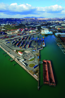

The Saone and I have for long formed a major corridor and trading route that links Northern Europe with the Mediterranean. The 19th century was the age of the railway and so I underwent a period of decline. It was necessary to await CNR’s developments to open me up to wide gauge navigation along 330 km, between Lyon and the Mediterranean, to really launch navigation in the Rhone Valley. Today, 18 industrial and port sites mesh the Rhone Valley while the Port de Lyon handles 12 million tonnes of goods a year.
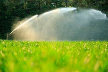
Irrigation and industrial uses
I irrigate a total of 221,000 hectares of farmland, of which 120,000 hectares are made irrigable by the CNR thanks to 170 water inlets. 50% of withdrawals of water taken from my tributaries and surface water are used to improve the productivity of the crops that cover my land. In the Drome department, the region’s leading agricultural department, 80% of the volumes used to irrigate crops are taken from my waters and those of the river Isère.

Agriculture in the Rhone Valley is diverse both in terms of the size of farms and types of crop, but it is now confronted by major challenges: that of adapting to better manage increasingly scarce water resources, and that of being more energy efficient, while ensuring sufficient good quality production.
Besides agriculture, other sectors of activity need me: nuclear power plants use my water to cool their reactors; the chemical and petrochemical industries, and cement works.
Tourism and leisure reborn
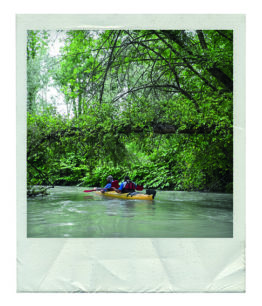

After taking decades to tame me, human beings now want to benefit from my touristic assets. My banks have been developed to allow people to stroll and ride bicycles, go roller skating, etc. Canoeists, swimmers, jousters and pleasure boaters also use my water for their leisure pursuits. The ViaRhôna, a cycle track that links Geneva with the Mediterranean, allows people to discover the territories I cross at their own rhythm.
More and more tourists also discover the beauty of my landscapes when sailing on river cruisers. A large number of landing stages have been built to berth these new river liners that ply my waters.
The Rhone Plan: a sustainable development project
Given the highly important stakes represented by my many uses and the need for solidarity between upstream and downstream, the political will to launch a project for global and interregional management emerged. The drafting of the Rhone Plan was accelerated by the major floods of 2002 and 2003. Although the initial aim was to define a flood prevention strategy, its extension to other themes was quickly justified. A second Rhone Plan was concluded for the period 2015-2020.
Three ambitions for the Rhone Plan
- Reconcile flood prevention and pressure to develop in floodable zones;
- Respect and improve the population’s living environment;
- Ensure the long-term economic development of this strategic territory.
It is organised around six thematic sections: heritage and culture, the prevention of flood risks, water quality, resource and biodiversity, energy, river transport and tourism.