News
All the newsA new border on the River Maroni

On 15 March, Suriname and France officially recognised the border drawn between the two countries on the Maroni, along more than 400 km. For both sides of the river, this agreement puts an end to four centuries of ambiguities and relaunches cooperation for better governance.
A historic agreement
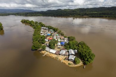
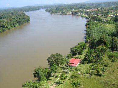
Local communities such as the Amerindians and the Bushinenge have always occupied the two banks of the Moroni without distinction. The Moroni is a wild river that separates French Guiana and Suriname, formerly Dutch Guiana, which became independent in 1975. During a working session organised in 2019, IFGR’s members were able to observe the situation: a river basin with a life and culture of its own, and a wealth of ethnic groups, the Maroni is anything but an administrative border. An identity around the river has been built over the centuries and the populations lay claim to it without any notion of nationality or land rights.

However, the haze that surround the border has increasingly become a source of diplomatic conflict and hampered cooperation to combat various forms of illicit traffic. Begun in 2019, the negotiations resulted in the signature of an agreement on 15 March 2021, between the French and Surinamese authorities, four centuries after the arrival of European colonists. An indisputable border finally forms an official separation between the two countries, on the downstream and middle parts of the basin, from the mouth of the river to Antecume Pata.
Drawing this 450 km long border along the river and its tributary, the Lawa, scattered with more than 900 islets, obliged the French and Surinamese authorities to carry out long and painstaking work in the field, making contacts with the local populations and the systematic visual surveying of these islets, facilitated by satellite technology. The aim is also to define the criteria to determine sovereignty over the hamlets, the nationality of the investments made (landing stages, shelters, electro-generators), and the sense of belonging of the population.
The negotiations must continue for the portion of the river furthest south, upstream of Antecume Pata and the confluence between the Litani and the Marouini. In this still contested region covering 6,000 km2, the hydrographic network forms a skein of countless branches of the river and its tributaries and islets, punctuated by myriad rapids and waterfalls. France is claiming a fixed border along the Litani, whereas Suriname situates it further east, on the Marouini.
The need for cross-border cooperation
This key diplomatic step opens up major perspectives for this region, riven with security, health and environmental problems. What is more the region is undergoing considerable demographic and ecological transition whose future, more than elsewhere, is determined by its river.


A declaration on “the common management of the Rivers Maroni and Lawa” was also signed on this occasion. It covers the combat against illegal gold prospection, the protection of the river and its populations, the development and maintenance of the banks, etc. This agreement provides new impetus to cooperation between the two countries, in particular by stipulating consultation for any project having an impact on the water of the river. Over the last few decades, problems of cross-border cooperation have encouraged the development of illegal gold prospection, a genuine scourge for the environment (destruction of river beds, deforestation) and health (contamination of water by mercury) and security. According to the Amazonian Park of Guiana, of the 148 illegal mining sites in the park, 85% were in the Maroni basin in January 2021 and benefited from cross-border logistic aid.
The Bio-Plateaux cooperation project launched in 2018 also participates in sharing knowledge and experience on water and biodiversity in aquatic habitats for the cross-border watersheds of the Maroni (between French Guiana and Suriname) and the Oyapock (between French Guiana and the federal state of Amapá in Brazil). It has led to the implementation of a cross-border observatory to produce and disseminate data and strengthen capacities.
For further information on the history of this border between Suriname and French Guiana, the geopolitics of drawing a line, read the scientific article by Patrick Blancodini, on the Géoconfluences site, October 2019