News
All the newsDiscovery: a new history of the Mississippi, at the crossroads of map-making, digital technology and art
Dan Coe, a cartographer for the Washington Geological Survey, has an obsession, that of exploring the aesthetic dimension of science, nature and geography. He recently performed the task of comparing old maps of the Mississippi delta, dating from the 1940s, and aerial laser data obtained using Lidar technology. The result is striking.
The memory of the river…
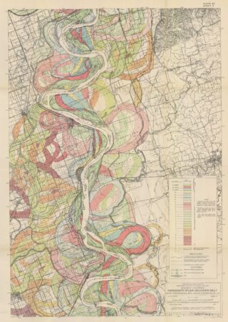

The maps made by the geologist Harold Fisk for a report by the Army Corps of Engineers in the 1940s are considered to be a reference by experts. He mapped the lower course of the Mississippi with remarkable precision and detail, showing the changes that had occurred in the riverbed over time. The research behind these maps is just as impressive as the maps themselves. Fisk and his team carried out long studies, taking 16,000 samples of soil around the river, and combined them with aerial photographs and local maps to define old flow paths. The keystone of his work comprised 15 maps showing the Mississippi’s meanders and the surrounding floodplains, from the Missouri to southern Louisiana. They represent the memory of a powerful river, as well as of the populations that have settled along its banks over the centuries.
… Revisited by Lidar


Seven decades later, Daniel Coe, a cartographer for the Washington Geological Survey, took inspiration from these maps and wanted to enthuse new life into them, with greater precision and another aesthetic dimension (see his work on the site). To do this he turned to data from the digital era using Lidar technology, a system of laser pulses emitted from a airplane to measure the topography below. Collected by the US Geological Survey (USGS), these data detect the shape of the river, dwelling and infrastructures, natural elements (vegetation, trees, etc.) with high precision. By reworking this database and eliminating or maintaining different layers – vegetation, infrastructures built by man (levees, diversions, buildings, etc.), Daniel Coe rediscovered the natural state of the river, with its meanders and transformations. Revisiting the traces left on the landscape by the Mississippi allowed him to better understand how it reacts to erosion, floods and landslides. Besides being a technical contribution, the aesthetic result is striking!