News
All the newsFreeing the bed of the Loire from its corset of groynes to give it a new lease of life
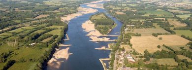

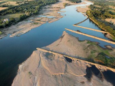
Since the beginning of September, large scale works supervised by VNF have been carried out on a section of France’s longest river, upstream of Nantes. The aim is to reduce and lower 23 groynes. These groynes are stone walls built on the bed of the river in the 19th century. The aim is to rebalance the riverbed which collapsed over a century ago, and restore more natural fluvial functioning.

A living river in a built-up space
 Although the Loire has been far less subject to development and artificialisation than the other large French rivers, leading it to be qualified as the “last great wild river of Europe”, it is nonetheless affected by human activities that began far back in history. The first dikes were built alongside the river as early as the middle-ages. The following centuries saw increasing works on the Loire built to exploit it, protect against it and cross it, with the construction of canals and navigation structures. River traffic reached a peak in the 18th century, with 4 to 5,000 boats sailing on it every year. To facilitate their circulation in this river known for its floods and sand banks, engineers had to design wall structures that protruded into the river crosswise and dredge a deeper central channel that could be used all year round. The wide main bed, otherwise free and meandering, was corseted by more than 750 groynes built between Angers and Nantes. At the beginning of the 20th century, boats could sail 150 km upstream from the estuary. Human intervention did not stop there: during the 19th and 20th centuries, the river was dredged to extract huge quantities of sand required for construction, and to facilitate the irrigation of farmland.
In spite of the improvements made, the Loire has never been easy to navigate. The advent of the train, then the development of road traffic, progressively extinguished the economic advantage of river navigation in the middle of the 19th century. Agricultural uses also changed. Men no longer intervened except to protect themselves from floods and ensure there was enough water in the river to cool nuclear power plants.
A change of paradigm
In the 1980s, a new project to develop the Loire was fiercely disputed by civil society which had set up the association SOS Loire Vivante (SOS Living Loire): the project planned for the construction of several large dams intended to reduce floods and raise the low water level.
Thanks to this campaign, which brought the project to a halt, a new political vision for the management of the Loire basin emerged: soft management of the river rather than development, which set in place a new framework in which human activities had to adjust to the demands of the environment rather than the contrary (cf. scientific article by Sylvain Rode: From river development to river management: the Loire basin, a reflection of the evolution of relations between river development and the environment, 2010).
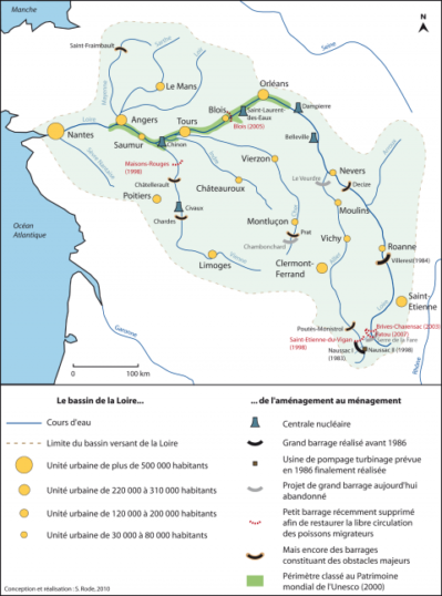
Indeed, the river was suffering: its bed had eroded, its aquatic environment had lost its diversity, and its sediments were blocked. Sand extractions were forbidden and the Plan Loire Grandeur Nature launched in 1994 by the government set out a 10-year programme to combine the safety of people and property with environmental protection and economic development. It included the cancellation of large dam projects, the restoration of the riverbed, the dismantling of two dams and the restoration of natural habitats.
On the downstream Loire, following the mobilization of local stakeholders, a reflection on the rebalancing of the river emerged in the 1990s. Several expert reports and experimental work were carried out: de-vegetation operations, remodeling of groins, creation of experimental sills implemented during the first 3 Loire Plans, between 1995 and 2017. They will lead to the construction, with the local stakeholders, of a shared action strategy to rebalance the bed of the Loire.
Inventing and fostering the balance of the river
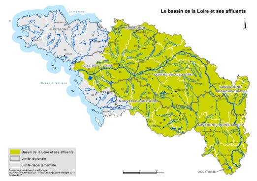
 In 2013, the State, the local Water Agency and the Pays de la Loire Region entrusted Voies Navigables de France (VNF) with the operational management of the first phase of the program to rebalance the bed of the Loire. As a national river operator, VNF is responsible for the hydraulic management of its infrastructure, in addition to guaranteeing its navigability, in addition to its missions to develop river transport and regional development.
VNF is launching more than 6.5 million euros worth of studies to translate the strategic objectives into operational actions. It is the result of experiments carried out in the field and hydrological studies using physical models built by CNR to a scale of 1/100 at its Hydraulic Structural Behaviour Analysis Centre (CACOH). This 35-foot-long model made it possible to analyse the displacement of sand and assess the efficiency of a new “transition” structure to raise the water level during low water periods. It reproduced a section of 3.5 km and completed a numerical model to simulate the natural evolution of sediments over 50 years, with one minute in the laboratory being equivalent to 24 hours in the wild!
Aimed at structuring the morphology of the river, the works carried out had two main objectives:
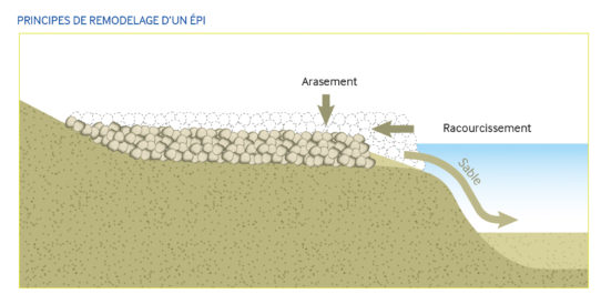
- Lower, reduce or eliminate the groynes in order to give the river back its freedom and reconnect its secondary branches. 140,000 m3 of riprap will be removed and the sediments freed will be deposited at points where the riverbed has been over-incised.

- Develop a transition area upstream of Nantes to favour the deposit of sediments and raise the water level.
.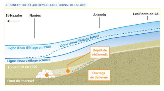

The riverbed had sunk from 1 to 4 metres during low water, depending on the reach. These structures in fact had three consequences, as explained by Séverine Gagnol, head of the territorial unit Loire Aval with Voies Navigables de France: “Firstly, the bed had become deeper due to the acceleration of the current and the groynes that blocked the sediment. Then the side branches dried. Lastly, the tides were able to travel further up the river, bringing salt water to merge with freshwater.”

Removing the groynes allows the sediment to join the central channel and reform the transient islets that existed before the developments. The river will become less deep and its current transporting sediment at a speed of 1 to 4 kilometres a year will slow down. The result: an increase in the height of the bed by 1 metre. Above all, the river will be permanently reconnected to its secondary branches. At present, this occurs only 30 to 50% of the time and, if nothing is done, this trend could be further reduced by 10 to 30% with climate change. By 2050, the discharge could be only half what it is now.
Restoring the dynamic functioning of the wetlands will spur the development of populations of fishes like the pike, lamprey and eel. It will also permit controlling the invasion of exotic species like the primrose willow;
Three sectors of action between Les Ponts de Cé (Maine-et-Loire) and Nantes (Loire-Atlantique) have been identified, i.e. a total length of 80 km. These works will last until 2025 and represent an investment of more than €41 million (excluding the studies) *.
The start of the works last September corresponds to the first phase of the works. Following heavy rainfall in the Loire basin at the end of September, the work had to be suspended. Indeed, in order to access the navigation groynes with the construction equipment, this work must be carried out at low water, when the Loire levels are the lowest (below 350 m3/s). The work will therefore resume in September 2022 in parallel with the second phase of the project.
Although restoring the Loire, listed as a UNESCO World Heritage Site, to a fully wild state is utopian, this huge and ambitious programme of works will greatly enhance its natural functioning.
* funded by the Agence de l’eau Loire Bretagne (45%), the Région Pays-de-la-Loire (30 %), the European Regional Development Fund – Loire Basin – FEDER Loire (20 %) and Voies Navigables de France (5 %).