News
All the newsGil Mahé (IRD): "The inner Niger delta, an exceptional natural environment"


Gil Mahé, director of research at the Institute of Research and Development (IRD) is a specialist in the great African rivers. Here, he shares his knowledge to provide better understanding of the mechanisms in play in the Inner Niger Delta, an extraordinary wetland. He also sets out its perspectives, with the predictable impacts of climate change on this habitat and above all on human activities.
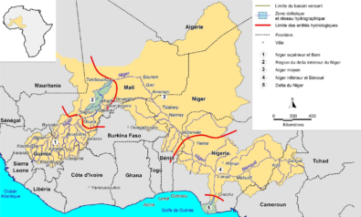
 The River Niger is bountiful in this region of the Sahel in West Africa, like the Nile in Egypt. Mainly supplied by the water from the mountains of Fouta-Djalon in Guinea, the north of the Ivory Coast and the entire south of Mali, the river defies the Sahara to provide a corridor of life. Human beings have for long learned to live with this river, and thanks to it, in the rhythm of its floods. The Inner Niger Delta, a vast area covering about 50,000 km², accommodates a million people, fishermen, livestock breeders and farmers who exploit the water and the soil. Although the environment changes cyclically over the year, it is increasingly changed by two other closely related phenomena: climatic risks and socioeconomic transformations. What is the future of this exceptional natural wetland?
Gil Mahé* is a director of research at the Institute of Research and Development (IRD) and a specialist of the great African rivers. For more than 30 years, he has studied the hydrology of these great rivers, the impacts of human activities and dams on the flows, and the fate of their resources. Here, he tells us about the situation.
The Inner Niger Delta is known to be an exceptional ecological habitat. Could you describe it for us?

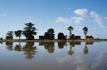
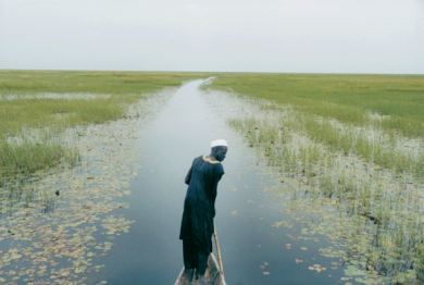
The Inner Niger Delta is characterised by a shallow slope and shallow waters. This immense area of freshwater that lies across this semi-arid land is absolutely exceptional. The flooded surface area can reach 35,000 km² in good years. Once you have been there, you can’t forget it. A wonderful sense of serenity envelopes you when you’re there.
The river is 1 km wide when it flows into the delta. The south of the delta comprises plains covered by a shallow depth of water with earth banks; in the centre the convergence of a large number of the river’s branches forms a string of lakes, the largest of which is Lake Débo. At its centre one can hardly see the banks; it’s huge, like the sea! The main channel finally zigzags between the dunes to the north.
Evaporation is very considerable in the inner delta. In years when the flood is not so high, with a correspondingly smaller flooded surface area, only 24% of the volume of water enters the delta, but in better years it reaches 48%, which is substantial and has local and even regional climatic implications.
The quantity of water that arrives in the delta depends on the rainfall in the upper basins of the River Niger and its main tributary, the Bani. Local rainfall contributes only from 5 to 10%! West and Central Africa were struck by severe drought in the 1970s and 80s, before more plentiful rains returned in the 1990s. The area is currently still short of water in comparison with measurements made in the 1950s and 60s. The shortage of water entering the delta has reached 69%, which obviously has an impact on the expansion of floods in the delta. However, this decreasing trend has stopped. Today’s levels are comparable to those of the middle of the 1970s.
The hydrological dynamics of the delta is complex and subject to substantial variability. The flows feeding it come from surface waters, rainwater runoff, and slow recharging from the groundwater. During the dry season, inflows come only from the groundwater.
Furthermore, the Niger delta is faced with the paradox of the Sahel: the flows do not diminish when lower rainfall is recorded; in addition, higher flows are measured for the same quantity of water. This stems from the long drought period which resulted in favouring flow conditions, with the reduction of vegetation. There is nothing to hold the water back, so it flows with greater velocity and power.
The drought of the 1970s and 80s led to a change in the flow regime which still causes surprise. At Niamey, the main flood of the Niger normally occurred between January and March. Now, the flood occurs in September, during the rainy season. The neighbourhoods close to the river are particularly vulnerable and the city is exposed to flooding. In August and September 2020, heavy rains caused historic floods, destroying part of the dikes along the river and claiming many lives.
This change of flood regime is exploited in the Inner Niger Delta: the additional water that arrives from July to September is used by the farmers who have deployed cofferdams to develop the low-lying land into nurseries for rice. Many farmers withdraw water directly from the river to irrigate their nurseries.
Dams also have an impact on discharges. Upstream of the inner delta, the hydropower dam of Sélingué on the Sankarani in particular, and to a lesser extent the weir of Markala, used to irrigate rice crops, have led to reducing the surface area flooded in the delta by regulating the floods. Nonetheless, the impact remains limited and these infrastructures ensure the water heights required to ensure the river’s navigability throughout the year.
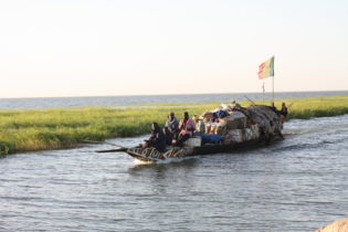
Contrary to what many people think, the dam does not dry up the river. In reality, it’s thanks to the dam that the river never dries, except in 1985 at Niamey at the height of the drought. The dam maintains a certain level of water in the river, including during the dry season. The Niger therefore provides a route for transport. Travelling overland is complicated and sometimes impracticable by car; what is more the region is prone to security problems. Transport is ensured practically exclusively on the river. Large boats cannot navigate during the dry season, but large pinnaces can sail throughout the year. The river allows transporting goods to the country’s local markets.
Nevertheless, caution is necessary regarding the development of West Africa’s hydraulic potential. In particular, I’m thinking about the project to build a dam at Fomi[1] in Guinea which will have a major impact, 3 times greater than the dam at Sélingué. The consequences will be considerable for the flow regime and that of the delta.
Fish resources are getting scarcer and the Sahara appears to be overwhelming the river. Are these transformations wholly imputable to climate change?
 We’ve seen more devastating floods over the last forty years. This is mainly due to a long period of lower floods, with populations occupying the spaces close to the river but which became more vulnerable with the return of severe floods, especially at the end of the rainy season in Niger. The lower force of the floods during these dry periods has also prevented the natural clearing of the river bed. Sand banks have formed in certain areas, in particular due to the Harmattan, a hot, dry wind that blows from the desert to the delta. Increased silting has led to more problems for navigation than before when the flow upstream of the river was stronger; it has above all reduced the period during which the largest boats can sail.
Inflows of water to the delta have decreased with climate change. There is less rainfall and less water in the delta, thus a smaller surface area flooded. However, there is no link of proportionality between the reduced rainfall and the fall in the level of water in the river. The lower rainfall alone does not suffice to explain the very marked reduction of floods. To understand this phenomenon, one must take into account that the flow in the river also comes from the groundwater. But successive years of meagre rainfall throughout West Africa has led to a major reduction in the level of water reserves in the aquifers, which in turn has contributed to ever less water in the surface flows of the River Niger. However, the rain in the basin is still substantial and contributes to triggering a flood that crosses the delta to join Niamey and the sea further on in Nigeria. So, the answer is no, the Sahara will not overwhelm the delta!
On the other hand, the dam of Fomi in Guinea will change things, since it will reduce the average height of the floods. Also, there is a link between the surface water and fish production. With the construction and commissioning of Fomi dam, fish production will decrease.
What links do the people maintain with the river delta?
 They’re close links, since human activities and their productivity are dictated by the rhythm of hydrological dynamics! One million people, meaning a tenth of Mali’s population, live on the delta, on a very large surface area. The delta is not densely populated. Its habitants depend on small subsistence farming, rice-growing, fishing and livestock breeding, although irrigated farming is increasing in the region.
The north is composed of a string of lakes that were regularly filled by the floods. The droughts have driven the population away from these spaces that have become areas of conflict. People have drawn closer to the river, densifying the dwellings and sometimes giving rise to disputes. Migrations have certainly occurred towards the towns, such as Timbuktu and Mopti.
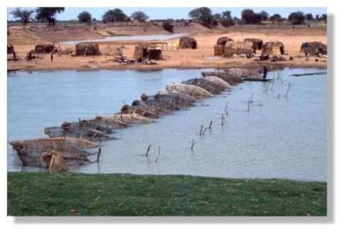
In the south part of the delta, large plains lay under the water during the floods. At the beginning of the floods the Peuls move north with their cattle towards the river to graze on the grass. Bourgou, which grows naturally in wetlands, is cultivated in the inner delta. The Peuls remain throughout the rainy season. These very flat areas are very important and permit feeding the cattle. The fishermen of the Bozo ethnic group also live with the floods that they follow like nomads. In the dry season, the fishermen withdraw to the banks along the main channel of the river. Then they install themselves at different points when the flood arrives. With climate change, fishing resources have become depleted, so the fishermen have become farmers. The occupations and movements of the populations are determined by the river.
What is the outlook? What solutions are being considered to preserve this ecosystem?
Rising temperatures will have a real impact on evaporation. For the area we’re talking about, the impact will not be so much on the delta, but downstream at its outlet: there’ll be less water. The models do not show much change until 2050. In comparison to the modifications that would be perhaps made by the Fomi dam, the transformations brought about by climate change appear relatively minor!
The River Niger is relatively easy to model upstream of the delta: there is a rainy season, a flood, no snow… However, for the inner delta, the situation is much more complicated since it is impossible to model the hydrological dynamics of such a dense and complex hydrological network in detail. What is more, the data accessible are not always reliable. The margin of error has become smaller with the development of new satellite data on water. Also, increasingly high-resolution satellite images make it possible to identify vulnerable areas.
Regarding international management and shared river governance, the Organisation for the Development of the Senegal River (OMVS), is well in advance with the protection of the natural regime of the wetlands and the populations who depend on them, with real-time information systems, databases, etc.
Also, the Niger Basin Authority (ABN) deserves some praise. With the contribution of the 9 countries crossed by the river, it has set up a real-time observation system and a large database shared by their governments. It focuses in particular on the river’s anthropisation in order to ensure flows that remain mostly natural, which is an exception for such a long river and a resource of such importance. Disaster movies that predict the disappearance of the river are counterproductive. No, the river will not disappear! However, it is vital to reconsider the link that we have with dams, since it cannot be what it was 50 years ago. The modifications that will occur to the river’s flow regime due to the forthcoming constructions, require in-depth studies on the fate of the flooded farmland in the delta, and on the impacts for the large local populations who live in rhythm with the floods of the river.

*Director of research at the Institute for Research and Development, Gil Mahé is a member of the Hydro-sciences laboratory at the University of Montpellier. He is the chairman of the scientific and coordination committee of UNESCO’s FRIEND-Water programme, which deploys 5 of its regional programmes in Africa. He is also a member of the scientific committee of UNESCO’s The World’s Large Rivers Initiative, president of the International Commission of Surface Water of the AISH and its Africa committee. Lastly, in 2015 he launched a series of conferences on the great rivers of Africa, the next edition of which will take place at Cotonou from 16 to 20 November 2021.
[1] The Fomi project is designed as a multipurpose dam (energy, irrigation, easing river navigation) and is included in the hydropower dam construction programme of the Guinean government. The project is still in the study phase and the final rating level for the dam has not yet been decided. A joint Guinea/Mali committee has been set up as a consultation body.
For more information: you can find several scientific papers co-written by Gil Mahé